Geolocate

Ardon topographic map

Click on the map to display elevation.

About this map
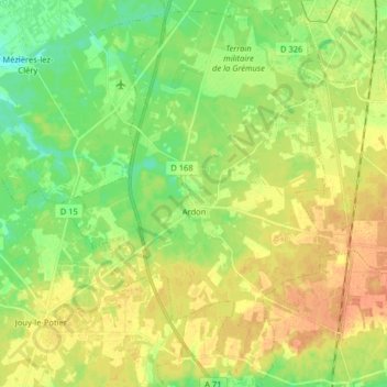
Name: Ardon topographic map, elevation, terrain.

Location: Ardon, Orléans, Loiret, Centre-Val de Loire, Metropolitan France, 45160, France (47.72859 1.82156 47.83636 1.92758)

Average elevation: 111 m

Minimum elevation: 93 m

Maximum elevation: 129 m

Other topographic maps

Click on a map to view its topography, its elevation and its terrain.

L' Île Arrault

France > Centre-Val de Loire > Loiret > Orléans

Average elevation: 102 m

La Motte Pétrée

France > Centre-Val de Loire > Loiret > Saran

Average elevation: 123 m

Le Village

France > Centre-Val de Loire > Loiret > Chevannes

Average elevation: 114 m

Au Bois d'Eau

France > Centre-Val de Loire > Loiret > Bricy

Average elevation: 123 m

Rougement

France > Centre-Val de Loire > Loiret > Loury

Average elevation: 124 m

Les Allots

France > Centre-Val de Loire > Loiret > Sandillon

Average elevation: 100 m

Gear up for your next adventure:

📻Hand-Crank Emergency Radios - Stay updated on weather warnings in remote areas
🪢Paracord - Multi-purpose cord for camping and survival
🥤Collapsible Water Bottles - Save space in your rucksack as you consume your water
🧢Thermal Beanie Hats - Prevent heat loss from the head in windy summit conditions
🧺Microfibre Travel Towels - Fast-drying and compact towels for wild swimming and camping

As an Amazon Associate, this site earns from qualifying purchases at no extra cost to you.