Geolocate

Paros topographic map

Click on the map to display elevation.

About this map

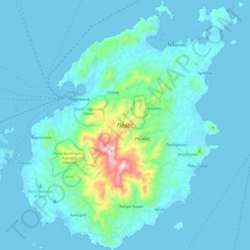
Name: Paros topographic map, elevation, terrain.

Location: Paros, Paros Regional Unit, South Aegean, Aegean, Greece (36.97506 25.09724 37.15530 25.29440)

Average elevation: 69 m

Minimum elevation: -1 m

Maximum elevation: 735 m

Other topographic maps

Click on a map to view its topography, its elevation and its terrain.

Livadia

Greece > Aegean > Paros Regional Unit > Naousa

Average elevation: 54 m

Pounta

Greece > Aegean > Paros Regional Unit

Average elevation: 21 m

Tsoukalia

Greece > Aegean > Paros Regional Unit

Average elevation: 18 m

Isterni

Greece > Aegean > Paros Regional Unit > Ampelas

Average elevation: 43 m

Gear up for your next adventure:

🥫Expedition Meals - Lightweight, high-calorie nutrition for long-distance hikers
🧭Orienteering Compasses - Accurate compasses for map-based navigation
🥤Hiking Water Bottles - Reusable bottles for hydration on the trail
🔦Keychain LED Torches - Emergency backup light for finding gear in your pack
🗺️Ordnance Survey Maps - Official UK maps for walking and outdoor activities

As an Amazon Associate, this site earns from qualifying purchases at no extra cost to you.