
Mariquita topographic map
Interactive map
Click on the map to display elevation.
About this map
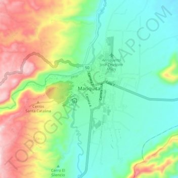
Name: Mariquita topographic map, elevation, terrain.
Location: Mariquita, Tolima, Colombia (5.15697 -74.93388 5.23697 -74.85388)
Average elevation: 545 m
Minimum elevation: 385 m
Maximum elevation: 862 m
Other topographic maps
Click on a map to view its topography, its elevation and its terrain.