
Mandalagan topographic map
Interactive map
Click on the map to display elevation.
About this map
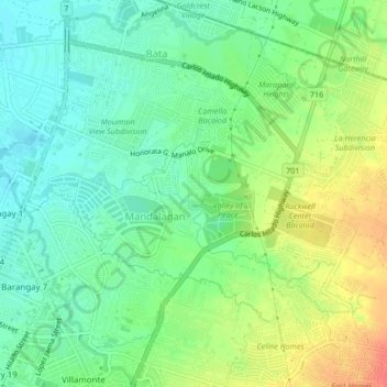
Name: Mandalagan topographic map, elevation, terrain.
Location: Mandalagan, Negros Occidental, Western Visayas, Filippine (10.67666 122.95451 10.70042 122.99643)
Average elevation: 22 m
Minimum elevation: 2 m
Maximum elevation: 53 m
Other topographic maps
Click on a map to view its topography, its elevation and its terrain.
Mandalagan
Filippine > Negros Occidental > Mandalagan
Mandalagan, Negros Occidental, Western Visayas, 6100, Filippine
Average elevation: 20 m