
Corne de Sorebois topographic map
Interactive map
Click on the map to display elevation.
About this map
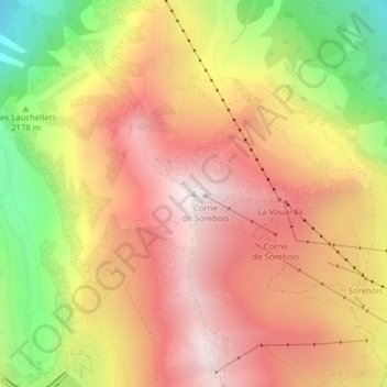
Name: Corne de Sorebois topographic map, elevation, terrain.
Average elevation: 2,404 m
Minimum elevation: 1,729 m
Maximum elevation: 2,884 m
Other topographic maps
Click on a map to view its topography, its elevation and its terrain.
Le Bouillet
Switzerland > Wallis > Sierre > Anniviers > Zinal
Le Bouillet, Zinal, Anniviers, Sierre, Wallis, 3961, Switzerland
Average elevation: 2,167 m
Vissoie
Switzerland > Wallis > Sierre > Anniviers
Vissoie, Anniviers, Sierre, Wallis, 3961, Switzerland
Average elevation: 1,599 m