
Link Lake topographic map
Interactive map
Click on the map to display elevation.
About this map
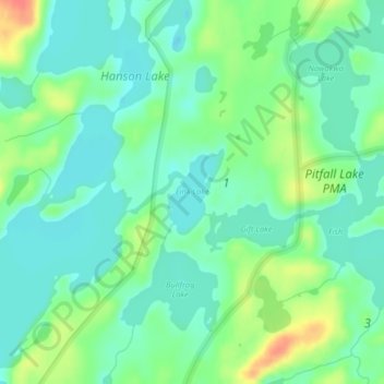
Name: Link Lake topographic map, elevation, terrain.
Location: Link Lake, Lake County, Minnesota, United States (48.14165 -91.07129 48.14774 -91.06151)
Average elevation: 452 m
Minimum elevation: 435 m
Maximum elevation: 488 m
Other topographic maps
Click on a map to view its topography, its elevation and its terrain.
Coffee Creek
United States > Minnesota > Lake County
Coffee Creek, Lake No. 1, Lake County, Minnesota, United States
Average elevation: 521 m
Alice Lake
United States > Minnesota > Lake County
Alice Lake, Fall Lake Township, Lake County, Minnesota, United States
Average elevation: 474 m
North Shore Mining/Lake Superior Overlook
United States > Minnesota > Lake County > Silver Bay
North Shore Mining/Lake Superior Overlook, City Shop Road, Silver Bay, Lake County, Minnesota, 55614, United States
Average elevation: 252 m
Fulton Creek
United States > Minnesota > Lake County
Fulton Creek, Lake County, Minnesota, United States
Average elevation: 560 m
Quartz Lake
United States > Minnesota > Lake County
Quartz Lake, Lake County, Minnesota, United States
Average elevation: 471 m
Jackfish Lake
United States > Minnesota > Lake County
Jackfish Lake, Lake County, Minnesota, United States
Average elevation: 411 m
Cook Lake
United States > Minnesota > Lake County
Cook Lake, Lake County, Minnesota, United States
Average elevation: 534 m
Bonnie Lake
United States > Minnesota > Lake County
Bonnie Lake, Lake County, Minnesota, United States
Average elevation: 437 m
Makwa Lake
United States > Minnesota > Lake County
Makwa Lake, Lake County, Minnesota, United States
Average elevation: 509 m
Bright Lake
United States > Minnesota > Lake County
Bright Lake, Lake County, Minnesota, United States
Average elevation: 431 m
Isabella
United States > Minnesota > Lake County > Isabella
Isabella, Lake County, Minnesota, United States
Average elevation: 594 m
Raven Lake
United States > Minnesota > Lake County
Raven Lake, Lake County, Minnesota, United States
Average elevation: 507 m
Jack Lake
United States > Minnesota > Lake County
Jack Lake, Lake County, Minnesota, United States
Average elevation: 509 m
Pickerel Lake
United States > Minnesota > Lake County
Pickerel Lake, Lake County, Minnesota, United States
Average elevation: 435 m