
Make a donation
Gear up for your next adventure:
As an Amazon Associate, this site earns from qualifying purchases at no extra cost to you.
Camarda topographic map
Click on the map to display elevation.
Make a donation
Gear up for your next adventure:
As an Amazon Associate, this site earns from qualifying purchases at no extra cost to you.
Camarda
Camarda è una frazione della città dell'Aquila, situata alle pendici occidentali del Gran Sasso, a circa 800 m d'altitudine, lungo la strada statale 17-bis che da Bazzano sale a Campo Imperatore passando per Paganica, Tempera, Assergi e Fonte Cerreto, un tempo comune autonomo prima di essere aggregato al capoluogo ed ora sede della nona circoscrizione del comune.
Make a donation
Gear up for your next adventure:
As an Amazon Associate, this site earns from qualifying purchases at no extra cost to you.
About this map
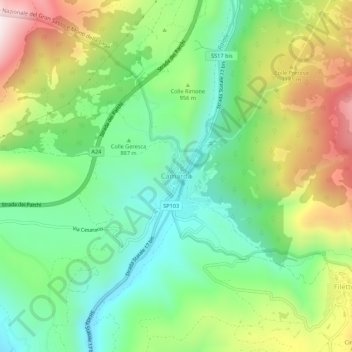
Name: Camarda topographic map, elevation, terrain.
Location: Camarda, L'Aquila, Abruzzo, Italia (42.37078 13.47415 42.41078 13.51415)
Average elevation: 955 m
Minimum elevation: 714 m
Maximum elevation: 1,359 m
Make a donation
Gear up for your next adventure:
As an Amazon Associate, this site earns from qualifying purchases at no extra cost to you.
Other topographic maps
Click on a map to view its topography, its elevation and its terrain.