
Le Pescher topographic map
Interactive map
Click on the map to display elevation.
About this map
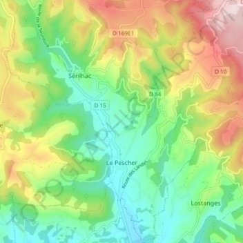
Name: Le Pescher topographic map, elevation, terrain.
Average elevation: 320 m
Minimum elevation: 166 m
Maximum elevation: 567 m
Other topographic maps
Click on a map to view its topography, its elevation and its terrain.
Ussel
France > Nouvelle-Aquitaine > Corrèze
The community of Ussel is located in the Massif central on the foothills of the plateau de Millevaches. The city itself sits on a hilltop in between the valley of the river Diège and the valley of the river Sarsonne. It is situated at an altitude of 2070 ft (631 m), in the Massif Central on the last buttress…
Average elevation: 680 m