Kutai Kertanegara topographic map
Interactive map
Click on the map to display elevation.
About this map
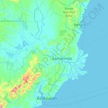
Name: Kutai Kertanegara topographic map, elevation, terrain.
Average elevation: 40 m
Minimum elevation: -4 m
Maximum elevation: 1,122 m

Click on the map to display elevation.
Name: Kutai Kertanegara topographic map, elevation, terrain.
Average elevation: 40 m
Minimum elevation: -4 m
Maximum elevation: 1,122 m