
Teton County topographic map
Interactive map
Click on the map to display elevation.
About this map
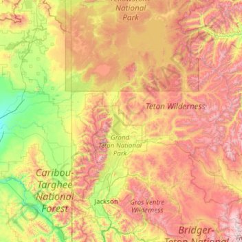
Name: Teton County topographic map, elevation, terrain.
Location: Teton County, Wyoming, Vereinigte Staaten von Amerika (43.23474 -111.05338 44.66681 -110.05103)
Average elevation: 2,400 m
Minimum elevation: 1,519 m
Maximum elevation: 4,043 m
Other topographic maps
Click on a map to view its topography, its elevation and its terrain.
Yellowstone Caldera Supervolcano
Vereinigte Staaten von Amerika > Wyoming > Teton County
Yellowstone Caldera Supervolcano, Teton County, Wyoming, Vereinigte Staaten von Amerika
Average elevation: 2,530 m
Two Ocean Pass
Vereinigte Staaten von Amerika > Wyoming > Teton County
Two Ocean Pass, Teton County, Wyoming, Vereinigte Staaten von Amerika
Average elevation: 2,576 m
Rocky Mountains
Vereinigte Staaten von Amerika > Wyoming > Teton County
Rocky Mountains, Teton County, Wyoming, Vereinigte Staaten von Amerika
Average elevation: 2,292 m
Yellowstone Lake
Vereinigte Staaten von Amerika > Wyoming > Teton County
Yellowstone Lake, Teton County, Wyoming, Vereinigte Staaten von Amerika
Average elevation: 2,453 m