Geolocate

Wiarton topographic map

Click on the map to display elevation.

About this map

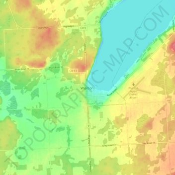
Name: Wiarton topographic map, elevation, terrain.

Location: Wiarton, South Bruce Peninsula, Bruce County, Ontario, N0H 2T0, Canada (44.70383 -81.18082 44.78383 -81.10082)

Average elevation: 205 m

Minimum elevation: 169 m

Maximum elevation: 248 m

Other topographic maps

Click on a map to view its topography, its elevation and its terrain.

Brockton

Canada > Ontario > Bruce County

Average elevation: 275 m

South Bruce

Canada > Ontario > Bruce County > South Bruce

Average elevation: 315 m

Gear up for your next adventure:

🛰️Satellite Messengers - Emergency communication devices for areas without mobile signal
🎒Backpack Rain Covers - Universal waterproof covers to protect your gear from downpours
🛰️Handheld GPS Devices - Reliable GPS units for hiking and outdoor navigation
🧺Ultralight Dry Bags - Organize and waterproof your gear inside your rucksack
🧤Hiking Gloves - Warm and durable gloves for cold-weather walks

As an Amazon Associate, this site earns from qualifying purchases at no extra cost to you.