Geolocate

Song County topographic map

Click on the map to display elevation.

About this map

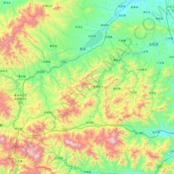
Name: Song County topographic map, elevation, terrain.

Location: Song County, Luoyang, Henan, China (33.56382 111.70417 34.34668 112.37111)

Average elevation: 773 m

Minimum elevation: 216 m

Maximum elevation: 2,151 m

Other topographic maps

Click on a map to view its topography, its elevation and its terrain.

Beicun

China > Henan > Luoyang

Average elevation: 469 m

Gear up for your next adventure:

🪓Outdoor Multitools - Versatile tools for hiking and camping
📷Outdoor Action Cameras - Cameras designed for hiking and adventure
🧺Microfibre Travel Towels - Fast-drying and compact towels for wild swimming and camping
❄️Walking Crampons - Added traction for icy slopes and winter peak bagging
🧭Emergency Beacons - Safety beacons for remote outdoor locations

As an Amazon Associate, this site earns from qualifying purchases at no extra cost to you.