Geolocate

Neipperg topographic map

Click on the map to display elevation.

About this map

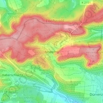
Name: Neipperg topographic map, elevation, terrain.

Location: Neipperg, Brackenheim, Verwaltungsgemeinschaft Brackenheim, Landkreis Heilbronn, Baden-Württemberg, 74336, Germany (49.08549 9.02856 49.12549 9.06856)

Average elevation: 268 m

Minimum elevation: 198 m

Maximum elevation: 338 m

Other topographic maps

Click on a map to view its topography, its elevation and its terrain.

Gear up for your next adventure:

🛰️Handheld GPS Devices - Reliable GPS units for hiking and outdoor navigation
🔪Outdoor Multi-Tools - Versatile tools for gear repairs and food prep in the wild
GPS Outdoor Watches - Watches with GPS tracking for hiking and exploration
🗺️Topographic Maps - Detailed maps showing elevation and terrain features
👕Technical Hiking Tees - Moisture-management for high-exertion climbs

As an Amazon Associate, this site earns from qualifying purchases at no extra cost to you.