
Chirivel topographic map
Interactive map
Click on the map to display elevation.
About this map
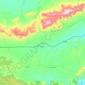
Name: Chirivel topographic map, elevation, terrain.
Location: Chirivel, Los Vélez, Almería, Andalusien, 04825, Spanien (37.53834 -2.39127 37.67213 -2.15338)
Average elevation: 1,205 m
Minimum elevation: 853 m
Maximum elevation: 2,043 m
Other topographic maps
Click on a map to view its topography, its elevation and its terrain.
Vélez-Rubio
Spanien > Andalusien > Los Vélez
Vélez-Rubio, Los Vélez, Almería, Andalusien, 04820, Spanien
Average elevation: 944 m