
Thank you for supporting this site ❤️
Make a donation
Make a donation
Gear up for your next adventure:
As an Amazon Associate, this site earns from qualifying purchases at no extra cost to you.
Porqueres topographic map
Click on the map to display elevation.
Thank you for supporting this site ❤️
Make a donation
Make a donation
Gear up for your next adventure:
As an Amazon Associate, this site earns from qualifying purchases at no extra cost to you.
About this map
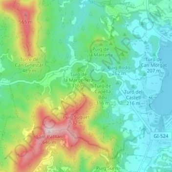
Name: Porqueres topographic map, elevation, terrain.
Location: Porqueres, Pla de l'Estany, Girona, Catalonia, Spain (42.10119 2.69681 42.14731 2.75520)
Average elevation: 301 m
Minimum elevation: 168 m
Maximum elevation: 622 m
Thank you for supporting this site ❤️
Make a donation
Make a donation
Gear up for your next adventure:
As an Amazon Associate, this site earns from qualifying purchases at no extra cost to you.