
Tunggulwulung topographic map
Interactive map
Click on the map to display elevation.
About this map
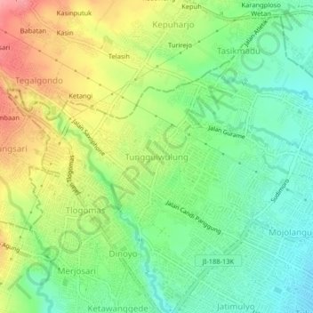
Name: Tunggulwulung topographic map, elevation, terrain.
Average elevation: 514 m
Minimum elevation: 475 m
Maximum elevation: 570 m
Other topographic maps
Click on a map to view its topography, its elevation and its terrain.
RW 11 Kelurahan Merjosari Kecamatan Lowokwaru Kota Malang
Indonesia > East Java > Kota Malang > Malang
Average elevation: 597 m
RW 06 Kel. Kotalama Kec. Kedung Kandang, Kota Malang
Indonesia > East Java > Kota Malang > Malang > Kotalama
Average elevation: 434 m