Geolocate

Mount Merbabu topographic map

Click on the map to display elevation.

About this map

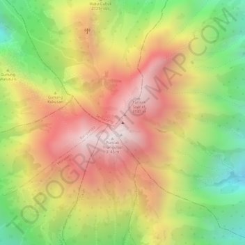
Name: Mount Merbabu topographic map, elevation, terrain.

Location: Mount Merbabu, Boyolali, Central Java, Java, Indonesia (-7.45249 110.44077 -7.45239 110.44087)

Average elevation: 2,696 m

Minimum elevation: 2,177 m

Maximum elevation: 3,123 m

Other topographic maps

Click on a map to view its topography, its elevation and its terrain.

Cepogo

Indonesia > Central Java > Boyolali

Average elevation: 1,308 m

Cluntang

Indonesia > Central Java > Boyolali

Average elevation: 1,033 m

Gear up for your next adventure:

🧢Thermal Beanie Hats - Prevent heat loss from the head in windy summit conditions
🛌Insulated Sleeping Mats - Crucial thermal protection when sleeping on cold, uneven ground
📍Handheld GPS Navigators - Reliable satellite navigation for hiking and off-road exploration
💧Hydration Reservoirs - Convenient water bladders for hands-free drinking on the move
🧥Breathable Waterproof Jackets - Essential rain protection for the unpredictable British climate

As an Amazon Associate, this site earns from qualifying purchases at no extra cost to you.