
Tuktuk Siadong topographic map
Interactive map
Click on the map to display elevation.
About this map
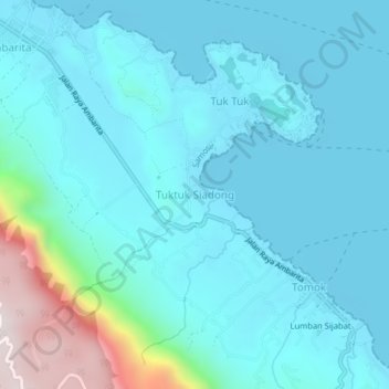
Name: Tuktuk Siadong topographic map, elevation, terrain.
Location: Tuktuk Siadong, Samosir, North Sumatra, 22395, Indonesia (2.64225 98.82966 2.68225 98.86966)
Average elevation: 1,011 m
Minimum elevation: 895 m
Maximum elevation: 1,680 m
Other topographic maps
Click on a map to view its topography, its elevation and its terrain.
Hutaparik
Indonesia > North Sumatra > Samosir > Pangururan
Hutaparik, Pangururan, Samosir, North Sumatra, Sumatra, 22392, Indonesia
Average elevation: 994 m