
Medina of Tunis topographic map
Interactive map
Click on the map to display elevation.
About this map
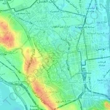
Name: Medina of Tunis topographic map, elevation, terrain.
Location: Medina of Tunis, الأسواق, معتمدية المدينة, Tunis, Tunisia (36.79191 10.16544 36.80529 10.17669)
Average elevation: 16 m
Minimum elevation: 0 m
Maximum elevation: 54 m
In the case of domestic architecture, the more a building is set back from the shops, the more it is valued. The concept of withdrawal and privacy is paramount. The late introduction of a sewer system means that much waste water still flows through the streets of the Medina. The largest houses and noble places are generally located in the district with the highest elevation, the Kasbah quarter. The roof terraces of the Medina are also an important place for social life, as illustrated by the film Halfaouine by Férid Boughedir.