
Lac Le Tars topographic map
Interactive map
Click on the map to display elevation.
About this map
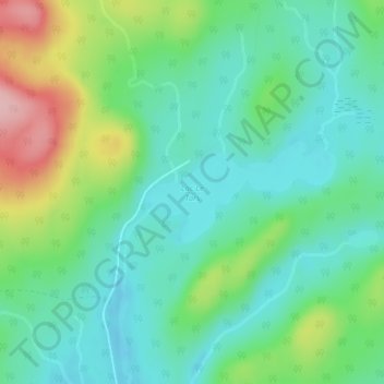
Name: Lac Le Tars topographic map, elevation, terrain.
Average elevation: 477 m
Minimum elevation: 427 m
Maximum elevation: 597 m
Other topographic maps
Click on a map to view its topography, its elevation and its terrain.
Lac Leslie
Canada > Québec > Lac-Legendre
Lac Leslie, 6, Lac-Legendre, Matawinie, Lanaudière, Québec, Canada
Average elevation: 490 m
Rivière Matawin
Canada > Québec > Lac-Legendre
Rivière Matawin, Lac-Legendre, Matawinie, Lanaudière, Québec, Canada
Average elevation: 522 m
Baie des Dix Milles
Canada > Québec > Lac-Legendre
Baie des Dix Milles, Lac-Legendre, Matawinie, Lanaudière, Québec, Canada
Average elevation: 453 m
Lac Azur
Canada > Québec > Lac-Legendre
Lac Azur, Lac-Legendre, Matawinie, Lanaudière, Québec, Canada
Average elevation: 501 m