Pandi topographic map
Click on the map to display elevation.
Pandi
Pandi is rich in many natural brooks coming from the mainland itself. In some remote areas the lands are still covered by bamboo trees that naturally thrive and multiplies. Some lands privately owned have mango plantations. In some areas that are privately owned are rock deposits being used for housing materials. The eastern area of Poblacion is gifted by the natural panoramic beauty of the scenery of Sierra Madre Mountains in Luzon. Owing to this the morning climate is always cloudy and cool in some areas of the town proper of Pandi, Bulacan. Some of the natural variations in topography of Pandi land areas have been evened out due to the urbanization of the town. The town's central area has been altered substantially by commercial establishments.
About this map
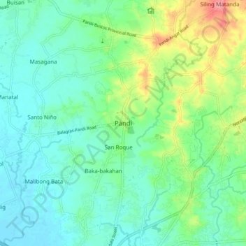
Name: Pandi topographic map, elevation, terrain.
Location: Pandi, Bulacan, Central Luzon, 3022, Philippines (14.82541 120.91725 14.90541 120.99725)
Average elevation: 27 m
Minimum elevation: 3 m
Maximum elevation: 90 m
Other topographic maps
Click on a map to view its topography, its elevation and its terrain.
Biak na Bato National Park
Philippines > Bulacan > Doña Remedios Trinidad > Talbak
Average elevation: 127 m