Geolocate

Cobham topographic map

Click on the map to display elevation.

Cobham

The River Mole runs through Cobham, with a visitor area and well-surfaced path by the mill in the High Street, dividing the low-rise urban village/town centre from the remaining agricultural parts of Cobham in the west and south. This can flood small, old parts of the village centre in extreme rainfall. Elevation reaches a minimum here of 20 metres (66 ft) above sea level.

Wikipedia (CC-BY-SA 3.0)

About this map

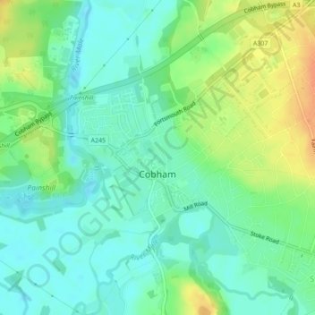
Name: Cobham topographic map, elevation, terrain.

Location: Cobham, Elmbridge, Surrey, England, United Kingdom (51.32439 -0.42790 51.33843 -0.39933)

Average elevation: 28 m

Minimum elevation: 14 m

Maximum elevation: 51 m

Surrey trails, hiking, mountain biking, running and outdoor activities

Other topographic maps

Click on a map to view its topography, its elevation and its terrain.

Weybridge

United Kingdom > England > Surrey > Elmbridge

Average elevation: 21 m

Horns Hill

United Kingdom > England > Surrey > Elmbridge > Oxshott

Average elevation: 56 m

St George's Hill

United Kingdom > England > Surrey > Elmbridge

Average elevation: 41 m

Downside

United Kingdom > England > Surrey > Elmbridge

Average elevation: 35 m

Whiteley Village

United Kingdom > England > Surrey > Elmbridge

Average elevation: 35 m

Clarendon Park

United Kingdom > England > Surrey > Elmbridge > Oxshott

Average elevation: 45 m

Hatchford

United Kingdom > England > Surrey > Elmbridge

Average elevation: 37 m

West End

United Kingdom > England > Surrey > Elmbridge

Average elevation: 24 m

Hurst Park

United Kingdom > England > Surrey > Elmbridge > Molesey

Average elevation: 12 m

West End Common

United Kingdom > England > Surrey > Elmbridge > West End

Average elevation: 28 m

Stokes Field Pond

United Kingdom > England > Surrey > Elmbridge

Average elevation: 23 m

Gear up for your next adventure:

🧥Softshell Jackets - Breathable jackets for active outdoor use
🧊Personal Water Filters - Drink safely from mountain streams marked on your map
🧣Fleece Neck Warmers - Extra insulation for winter topographic surveys
🧢Waterproof Hiking Hats - Keep the rain off your face while studying topographic maps
🎒Hiking Daypacks (20L) - Compact backpacks for day trips and technical mountain ascents

As an Amazon Associate, this site earns from qualifying purchases at no extra cost to you.