
Edinburgh topographic map
Interactive map
Click on the map to display elevation.
About this map
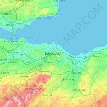
Name: Edinburgh topographic map, elevation, terrain.
Average elevation: 104 m
Minimum elevation: -3 m
Maximum elevation: 578 m
Some have called Edinburgh the Athens of the North for a variety of reasons. The earliest comparison between the two cities showed that they had a similar topography, with the Castle Rock of Edinburgh performing a similar role to the Athenian Acropolis. Both of them had flatter, fertile agricultural land sloping down to a port several miles away (respectively Leith and Piraeus). Although this arrangement is common in Southern Europe, it is rare in Northern Europe. The 18th-century intellectual life, referred to as the Scottish Enlightenment, was a key influence in gaining the name. Such luminaries as David Hume and Adam Smith shone during this period. Having lost most of its political importance after the Union, some hoped that Edinburgh could gain a similar influence on London as Athens had on Rome. Also a contributing factor was the later neoclassical architecture, particularly that of William Henry Playfair, and the National Monument. Tom Stoppard's character Archie, of Jumpers, said, perhaps playing on Reykjavík meaning "smoky bay", that the "Reykjavík of the South" would be more appropriate.
Other topographic maps
Click on a map to view its topography, its elevation and its terrain.
Pentland Hills Regional Park
United Kingdom > Scotland > Edinburgh > Peggyslea
Pentland Hills Regional Park, Dreghorn Link, Colinton Mains, Fairmilehead, Edinburgh, City of Edinburgh, Scotland, EH13 9QR, United Kingdom
Average elevation: 249 m
Leith Links
United Kingdom > Scotland > Edinburgh
Leith Links, Edinburgh, City of Edinburgh, Scotland, United Kingdom
Average elevation: 15 m
Firth of Forth
United Kingdom > Scotland > Edinburgh
Firth of Forth, Berwickshire, Scotland, United Kingdom
Average elevation: 87 m
Blackford Hill
United Kingdom > Scotland > Edinburgh
Blackford Hill, Edinburgh, City of Edinburgh, Scotland, EH9 3HR, United Kingdom
Average elevation: 105 m
Portobello
United Kingdom > Scotland > Edinburgh
Portobello, Edinburgh, City of Edinburgh, Scotland, United Kingdom
Average elevation: 24 m
Mayfield
United Kingdom > Scotland > Edinburgh
Mayfield, Edinburgh, City of Edinburgh, Scotland, EH9 1SB, United Kingdom
Average elevation: 80 m
Duddingston Loch
United Kingdom > Scotland > Edinburgh
Duddingston Loch, Duddingston Road West, Duddingston Village, Northfield/Willowbrae, Edinburgh, City of Edinburgh, Scotland, EH15 3QE, United Kingdom
Average elevation: 64 m
Liberton and District
United Kingdom > Scotland > Edinburgh
Liberton and District, Edinburgh, City of Edinburgh, Scotland, United Kingdom
Average elevation: 116 m
Leith Harbour & Newhaven
United Kingdom > Scotland > Edinburgh
Leith Harbour & Newhaven, Edinburgh, City of Edinburgh, Scotland, United Kingdom
Average elevation: 7 m
West End
United Kingdom > Scotland > Edinburgh
West End, Edinburgh, City of Edinburgh, Scotland, United Kingdom
Average elevation: 59 m
Northfield/Willowbrae
United Kingdom > Scotland > Edinburgh
Northfield/Willowbrae, Edinburgh, City of Edinburgh, Scotland, United Kingdom
Average elevation: 53 m
Dunsapie Loch
United Kingdom > Scotland > Edinburgh
Dunsapie Loch, Queen's Drive, Duddingston Village, Northfield/Willowbrae, Edinburgh, City of Edinburgh, Scotland, EH15 3PY, United Kingdom
Average elevation: 60 m
Portobello Beach
United Kingdom > Scotland > Edinburgh
Portobello Beach, Figgate Court, The Durhams, Portobello, Edinburgh, City of Edinburgh, Scotland, EH15 1JQ, United Kingdom
Average elevation: 11 m
Craiglockhart Pond
United Kingdom > Scotland > Edinburgh
Craiglockhart Pond, Lockharton Avenue, Craiglockhart, Edinburgh, City of Edinburgh, Scotland, EH14 1BD, United Kingdom
Average elevation: 90 m
Lochend Loch
United Kingdom > Scotland > Edinburgh
Lochend Loch, Lochend Butterfly Way, Leith Links, Leith, Edinburgh, City of Edinburgh, Scotland, EH7 5FF, United Kingdom
Average elevation: 34 m
Trinity
United Kingdom > Scotland > Edinburgh
Trinity, Edinburgh, City of Edinburgh, Scotland, United Kingdom
Average elevation: 17 m
Swanston
United Kingdom > Scotland > Edinburgh > Swanston
Swanston, City of Edinburgh, Scotland, United Kingdom
Average elevation: 232 m
Leith Central
United Kingdom > Scotland > Edinburgh
Leith Central, Edinburgh, City of Edinburgh, Scotland, United Kingdom
Average elevation: 26 m
Torduff Hill
United Kingdom > Scotland > Edinburgh
Torduff Hill, Edinburgh, City of Edinburgh, Scotland, EH13 0PA, United Kingdom
Average elevation: 224 m
Straiton Place Park
United Kingdom > Scotland > Edinburgh
Straiton Place Park, Portobello, Edinburgh, City of Edinburgh, Scotland, United Kingdom
Average elevation: 12 m
Figgate Pond
United Kingdom > Scotland > Edinburgh
Figgate Pond, Hamilton Drive, Mountcastle, Northfield/Willowbrae, Edinburgh, City of Edinburgh, Scotland, EH15 1NP, United Kingdom
Average elevation: 25 m
St Margaret's Loch
United Kingdom > Scotland > Edinburgh
St Margaret's Loch, Queen's Drive, Northfield/Willowbrae, Edinburgh, City of Edinburgh, Scotland, EH8 8JA, United Kingdom
Average elevation: 59 m
Victoria Dock
United Kingdom > Scotland > Edinburgh
Victoria Dock, Edinburgh, City of Edinburgh, Scotland, United Kingdom
Average elevation: 7 m
Muirhouse/Salvesen
United Kingdom > Scotland > Edinburgh
Muirhouse/Salvesen, Edinburgh, City of Edinburgh, Scotland, United Kingdom
Average elevation: 29 m
Tollcross
United Kingdom > Scotland > Edinburgh
Tollcross, Edinburgh, City of Edinburgh, Scotland, United Kingdom
Average elevation: 76 m
Craigentinny/Meadowbank
United Kingdom > Scotland > Edinburgh
Craigentinny/Meadowbank, Edinburgh, City of Edinburgh, Scotland, United Kingdom
Average elevation: 18 m