
Make a donation
Gear up for your next adventure:
As an Amazon Associate, this site earns from qualifying purchases at no extra cost to you.
Chinon topographic map
Click on the map to display elevation.
Make a donation
Gear up for your next adventure:
As an Amazon Associate, this site earns from qualifying purchases at no extra cost to you.
Chinon
Topography has played a major role: the formerly fortified town was developed at the foot of the castle on the rocky outcrop, protecting the northern side, with the Vienne River in the south. Apart from the natural defensive protection on both sides, this fact makes a long narrow urban space, with the main streets running parallel to the river.
Make a donation
Gear up for your next adventure:
As an Amazon Associate, this site earns from qualifying purchases at no extra cost to you.
About this map
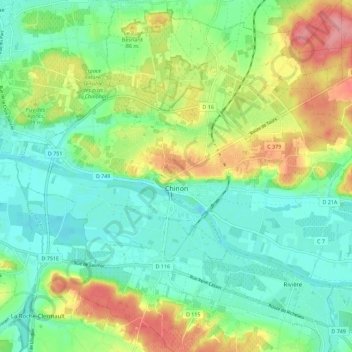
Name: Chinon topographic map, elevation, terrain.
Average elevation: 58 m
Minimum elevation: 24 m
Maximum elevation: 124 m
Make a donation
Gear up for your next adventure:
As an Amazon Associate, this site earns from qualifying purchases at no extra cost to you.
Other topographic maps
Click on a map to view its topography, its elevation and its terrain.
Le Clos des Chênes
France > Centre-Val de Loire > Indre-et-Loire > Chouzé-sur-Loire
Average elevation: 30 m
La Feuillarde
France > Centre-Val de Loire > Indre-et-Loire > Saint-Pierre-des-Corps
Average elevation: 55 m
La Diablerie
France > Centre-Val de Loire > Indre-et-Loire > Chanceaux-sur-Choisille
Average elevation: 111 m
Make a donation
Gear up for your next adventure:
As an Amazon Associate, this site earns from qualifying purchases at no extra cost to you.
Le Télégraphe
France > Centre-Val de Loire > Indre-et-Loire > Chambray-lès-Tours
Average elevation: 86 m
Le Grand Village
France > Centre-Val de Loire > Indre-et-Loire > La Ville-aux-Dames
Average elevation: 51 m
La Diablerie
France > Centre-Val de Loire > Indre-et-Loire > Chanceaux-sur-Choisille
Average elevation: 111 m
Make a donation
Gear up for your next adventure:
As an Amazon Associate, this site earns from qualifying purchases at no extra cost to you.
La Bérangerie
France > Centre-Val de Loire > Indre-et-Loire > Saint-Jean-Saint-Germain
Average elevation: 108 m
Make a donation
Gear up for your next adventure:
As an Amazon Associate, this site earns from qualifying purchases at no extra cost to you.
Le Bois Turbet
France > Centre-Val de Loire > Indre-et-Loire > Marcé-sur-Esves
Average elevation: 82 m