
Make a donation
Gear up for your next adventure:
As an Amazon Associate, this site earns from qualifying purchases at no extra cost to you.
Ingham CP topographic map
Click on the map to display elevation.
Make a donation
Gear up for your next adventure:
As an Amazon Associate, this site earns from qualifying purchases at no extra cost to you.
About this map
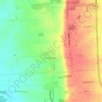
Name: Ingham CP topographic map, elevation, terrain.
Location: Ingham CP, West Lindsey, Lincolnshire, England, United Kingdom (53.33225 -0.61627 53.35338 -0.54378)
Average elevation: 39 m
Minimum elevation: 8 m
Maximum elevation: 74 m
Lincolnshire trails, hiking, mountain biking, running and outdoor activities
Make a donation
Gear up for your next adventure:
As an Amazon Associate, this site earns from qualifying purchases at no extra cost to you.
Other topographic maps
Click on a map to view its topography, its elevation and its terrain.
Make a donation
Gear up for your next adventure:
As an Amazon Associate, this site earns from qualifying purchases at no extra cost to you.
Caen Hill
United Kingdom > England > Lincolnshire > West Lindsey > Great Limber CP
Average elevation: 83 m
Make a donation
Gear up for your next adventure:
As an Amazon Associate, this site earns from qualifying purchases at no extra cost to you.
Rase Park
United Kingdom > England > Lincolnshire > West Lindsey > Market Rasen
Average elevation: 28 m
Make a donation
Gear up for your next adventure:
As an Amazon Associate, this site earns from qualifying purchases at no extra cost to you.
Bishopbridge
United Kingdom > England > Lincolnshire > West Lindsey > Osgodby CP
Average elevation: 10 m
Make a donation
Gear up for your next adventure:
As an Amazon Associate, this site earns from qualifying purchases at no extra cost to you.
Welton Cliff
United Kingdom > England > Lincolnshire > West Lindsey > Welton CP
Average elevation: 53 m
Make a donation
Gear up for your next adventure:
As an Amazon Associate, this site earns from qualifying purchases at no extra cost to you.
Limber Hill
United Kingdom > England > Lincolnshire > West Lindsey > Great Limber CP
Average elevation: 45 m
Make a donation
Gear up for your next adventure:
As an Amazon Associate, this site earns from qualifying purchases at no extra cost to you.
East Stockwith
United Kingdom > England > Lincolnshire > West Lindsey > East Stockwith
Average elevation: 5 m
Make a donation
Gear up for your next adventure:
As an Amazon Associate, this site earns from qualifying purchases at no extra cost to you.
Gate Burton
United Kingdom > England > Lincolnshire > West Lindsey > Marton > Gate Burton
Average elevation: 13 m
Scotterthorpe
United Kingdom > England > Lincolnshire > West Lindsey > Scotter CP > Scotterthorpe
Average elevation: 12 m
Make a donation
Gear up for your next adventure:
As an Amazon Associate, this site earns from qualifying purchases at no extra cost to you.