Geolocate

Indrayani topographic map

Click on the map to display elevation.

About this map

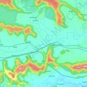
Name: Indrayani topographic map, elevation, terrain.

Location: Indrayani, Pune, Maharashtra, 411001, India (18.74668 73.44942 18.78436 73.60815)

Average elevation: 678 m

Minimum elevation: 571 m

Maximum elevation: 1,139 m

Other topographic maps

Click on a map to view its topography, its elevation and its terrain.

Wagholi

India > Maharashtra > Pune

Average elevation: 578 m

Sinhagad Vikas Udyan

India > Maharashtra > Pune

Average elevation: 580 m

Anandnagar

India > Maharashtra > Pune

Average elevation: 601 m

Wagholi

India > Maharashtra > Pune

Average elevation: 578 m

Katraj

India > Maharashtra > Pune

Average elevation: 662 m

Koregaon Park

India > Maharashtra > Pune

Average elevation: 555 m

Phulenagar

India > Maharashtra > Pune > Khadki

Average elevation: 557 m

Gear up for your next adventure:

📦Compression Sacks - Reduce backpack volume efficiently
🎒Multi-day Trekking Packs - Large capacity backpacks for wild camping and long-distance trails
🧥Softshell Jackets - Breathable jackets for active outdoor use
🧭GPS Trackers - Tracking devices for safety and navigation
🥤Hiking Water Bottles - Reusable bottles for hydration on the trail

As an Amazon Associate, this site earns from qualifying purchases at no extra cost to you.