
Thank you for supporting this site ❤️
Make a donation
Make a donation
Gear up for your next adventure:
As an Amazon Associate, this site earns from qualifying purchases at no extra cost to you.
Ventaquemada topographic map
Click on the map to display elevation.
Thank you for supporting this site ❤️
Make a donation
Make a donation
Gear up for your next adventure:
As an Amazon Associate, this site earns from qualifying purchases at no extra cost to you.
About this map
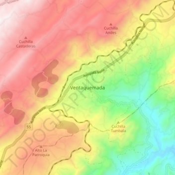
Name: Ventaquemada topographic map, elevation, terrain.
Location: Ventaquemada, Márquez, Boyacá, 153640, Colombia (5.32662 -73.56164 5.40662 -73.48164)
Average elevation: 2,813 m
Minimum elevation: 2,177 m
Maximum elevation: 3,383 m
Thank you for supporting this site ❤️
Make a donation
Make a donation
Gear up for your next adventure:
As an Amazon Associate, this site earns from qualifying purchases at no extra cost to you.