
Altdorf (UR) topographic map
Interactive map
Click on the map to display elevation.
About this map
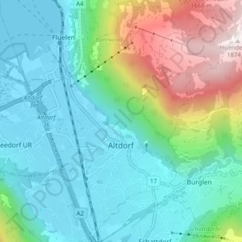
Name: Altdorf (UR) topographic map, elevation, terrain.
Location: Altdorf (UR), Uri, 6460, Switzerland (46.86364 8.61551 46.90976 8.66732)
Average elevation: 796 m
Minimum elevation: 431 m
Maximum elevation: 1,859 m
The municipality covers an area of 10.21 square kilometres (3.94 sq mi). The town proper sits at an altitude of 458 metres (1,503 ft) above sea level on a flat alluvial plain between the right bank of the river Reuss and the steep hillside of the Rossstock 2.4 km (1.5 mi) to the east. The scattered hamlets and pasteumreland of Eggbergen, about 1,000 metres (3,300 ft) above the town, also belong to the municipality.
Other topographic maps
Click on a map to view its topography, its elevation and its terrain.
Hospental
Switzerland > Uri > Korporation Ursern
Hospental, Korporation Ursern, Uri, 6493, Switzerland
Average elevation: 2,144 m
Realp
Switzerland > Uri > Korporation Ursern
Realp, Korporation Ursern, Uri, 6491, Switzerland
Average elevation: 2,282 m
Klausenpass
Switzerland > Uri > Unterschächen
Klausenpass, Unterschächen, Uri, 6465, Switzerland
Average elevation: 2,103 m
Oberalp
Switzerland > Uri > Unterschächen
Oberalp, Unterschächen, Uri, 6465, Switzerland
Average elevation: 1,900 m
Arnisee
Switzerland > Uri > Gurtnellen
Arnisee, Gurtnellen, Uri, Switzerland
Average elevation: 1,289 m
Sektor Spongebob
Switzerland > Uri > Wassen
Sektor Spongebob, Wassen, Uri, Switzerland
Average elevation: 2,189 m
Oberalppass
Switzerland > Uri > Korporation Ursern > Andermatt
Oberalppass, Andermatt, Korporation Ursern, Uri, 6490, Switzerland
Average elevation: 2,219 m
Glatten
Switzerland > Uri > Spiringen
Glatten, Spiringen, Uri, 8751, Switzerland
Average elevation: 2,090 m
Rhonegletscher
Switzerland > Uri > Korporation Ursern > Realp
Rhonegletscher, Realp, Korporation Ursern, Oberland administrative region, Uri, 6491, Switzerland
Average elevation: 2,802 m
Fleckistock
Switzerland > Uri > Wassen
Fleckistock, Wassen, Uri, Switzerland
Average elevation: 2,780 m
Andermatt
Switzerland > Uri > Korporation Ursern
Andermatt, Korporation Ursern, Uri, 6490, Switzerland
Average elevation: 2,127 m