
Mumbles topographic map
Click on the map to display elevation.
About this map
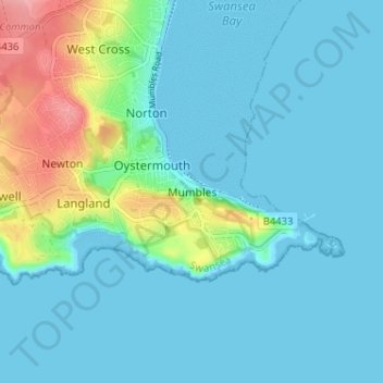
Name: Mumbles topographic map, elevation, terrain.
Location: Mumbles, Swansea, Wales, SA3 4DY, United Kingdom (51.55227 -4.01450 51.59227 -3.97450)
Average elevation: 19 m
Minimum elevation: -1 m
Maximum elevation: 105 m
Swansea trails, hiking, mountain biking, running and outdoor activities
Other topographic maps
Click on a map to view its topography, its elevation and its terrain.
River Loughor
United Kingdom > Wales > Swansea > Pontarddulais > Upper Loughor
Average elevation: 120 m