
Windsor Charter Township topographic map
Interactive map
Click on the map to display elevation.
About this map
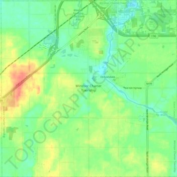
Name: Windsor Charter Township topographic map, elevation, terrain.
Average elevation: 271 m
Minimum elevation: 252 m
Maximum elevation: 302 m
Other topographic maps
Click on a map to view its topography, its elevation and its terrain.
West Windsor
United States > Michigan > Eaton County
West Windsor, Windsor Charter Township, Eaton County, Michigan, 48821, United States
Average elevation: 277 m
Little Venice
United States > Michigan > Eaton County > Little Venice
Little Venice, Roxand Township, Eaton County, Michigan, United States
Average elevation: 273 m
Eaton Rapids
United States > Michigan > Eaton County > Eaton Rapids
Eaton Rapids, Eaton County, Michigan, 48827, United States
Average elevation: 272 m