Geolocate

Thule topographic map

Click on the map to display elevation.

About this map

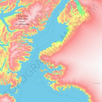
Name: Thule topographic map, elevation, terrain.

Location: Thule, Avannaata, 3971, Greenland (75.20648 -71.89462 81.16217 -43.97257)

Average elevation: 717 m

Minimum elevation: -1 m

Maximum elevation: 2,281 m

Other topographic maps

Click on a map to view its topography, its elevation and its terrain.

Kullorsuaq

Greenland > Avannaata

Average elevation: 28 m

Qaasuitsup

Greenland > Avannaata

Average elevation: 1,344 m

Nuussuaq

Greenland > Avannaata

Average elevation: 85 m

Thule

Greenland > Avannaata

Average elevation: 182 m

Upernavik

Greenland > Avannaata

Average elevation: 13 m

Ilulissat

Greenland > Avannaata

Average elevation: 67 m

Gear up for your next adventure:

🧭GPS Trackers - Tracking devices for safety and navigation
🎿Telescopic Trekking Poles - Reduces knee strain on steep topographic descents
🔋Rechargeable Batteries - Eco-friendly power for headlamps and older GPS units
🎒Hiking Daypacks - Compact backpacks ideal for short hikes and excursions
🎒Hiking Daypacks (20L) - Compact backpacks for day trips and technical mountain ascents

As an Amazon Associate, this site earns from qualifying purchases at no extra cost to you.