
Nods topographic map
Interactive map
Click on the map to display elevation.
About this map
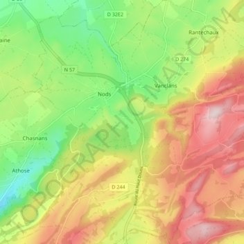
Name: Nods topographic map, elevation, terrain.
Average elevation: 778 m
Minimum elevation: 604 m
Maximum elevation: 973 m
Nods est un village de l'est de la France, situé sur le plateau de Vercel, à 720 mètres d'altitude. On y accède par la RN 57 entre Besançon et Pontarlier.
Other topographic maps
Click on a map to view its topography, its elevation and its terrain.
Le Petit Paris
France > Bourgogne-Franche-Comté > Doubs > Les Premiers-Sapins
Le Petit Paris, Chasnans, Les Premiers-Sapins, Pontarlier, Doubs, Bourgogne-Franche-Comté, France métropolitaine, 25580, France
Average elevation: 817 m