Geolocate

Raipur topographic map

Click on the map to display elevation.

About this map

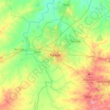
Name: Raipur topographic map, elevation, terrain.

Location: Raipur, Raipur Tahsil, Raipur, Chhattisgarh, 493332, India (21.07809 81.47370 21.39809 81.79370)

Average elevation: 288 m

Minimum elevation: 261 m

Maximum elevation: 326 m

Other topographic maps

Click on a map to view its topography, its elevation and its terrain.

Khokho Talab

India > Chhattisgarh > Raipur Tahsil > Raipur

Average elevation: 292 m

Mandi Gate Talab

India > Chhattisgarh > Raipur Tahsil > Raipur

Average elevation: 281 m

Gear up for your next adventure:

🧢Hiking Hats - Sun and weather protection for outdoor walks
🎒Hiking Daypacks (20L) - Compact backpacks for day trips and technical mountain ascents
GPS Outdoor Watches - Watches with GPS tracking for hiking and exploration
🔋Lithium AA Batteries - Long-lasting power that performs well in cold mountain weather
🧤Waterproof Overmitts - Extreme weather protection for hikers and mountaineers

As an Amazon Associate, this site earns from qualifying purchases at no extra cost to you.