Geolocate

Town of Rotterdam topographic map

Interactive map

Click on the map to display elevation.

About this map

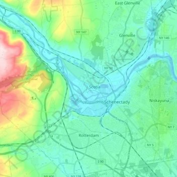
Name: Town of Rotterdam topographic map, elevation, terrain.

Location: Town of Rotterdam, Schenectady County, New York, United States (42.75297 -74.08726 42.89667 -73.90692)

Average elevation: 132 m

Minimum elevation: 60 m

Maximum elevation: 405 m

Other topographic maps

Click on a map to view its topography, its elevation and its terrain.

Village of Delanson

United States > New York > Schenectady County > Town of Duanesburg

Village of Delanson, Town of Duanesburg, Schenectady County, New York, 12053, United States

Average elevation: 290 m

Town of Niskayuna

United States > New York > Schenectady County

Town of Niskayuna, Schenectady County, New York, 12309, United States

Average elevation: 101 m

Glenville

United States > New York > Schenectady County > Glenville

Glenville, Town of Glenville, Schenectady County, New York, 12325, United States

Average elevation: 107 m

City of Schenectady

United States > New York > Schenectady County

City of Schenectady, Schenectady County, New York, 12345, United States

Average elevation: 100 m