
Prospect Hill topographic map
Interactive map
Click on the map to display elevation.
About this map
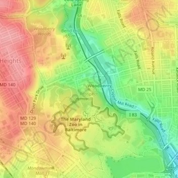
Name: Prospect Hill topographic map, elevation, terrain.
Location: Prospect Hill, Baltimore, Maryland, 21211, USA (39.32975 -76.64555 39.32985 -76.64545)
Average elevation: 85 m
Minimum elevation: 27 m
Maximum elevation: 131 m
Other topographic maps
Click on a map to view its topography, its elevation and its terrain.
Patterson Park
Patterson Park, Baltimore - Linwood, Baltimore, Maryland, USA
Average elevation: 17 m
Gwynns Falls Leakin Park
Gwynns Falls Leakin Park, Wakefield, Baltimore, Maryland, USA
Average elevation: 98 m
Cylburn Arboretum
Cylburn Arboretum, Cold Spring, Baltimore, Maryland, USA
Average elevation: 104 m