
Bethioua topographic map
Interactive map
Click on the map to display elevation.
About this map
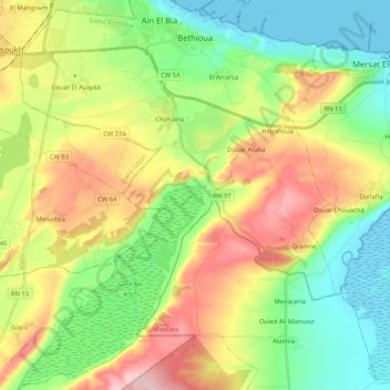
Name: Bethioua topographic map, elevation, terrain.
Location: Bethioua, Bethioua District, Oran, Algeria (35.65256 -0.36318 35.82204 -0.19304)
Average elevation: 83 m
Minimum elevation: -3 m
Maximum elevation: 214 m
Other topographic maps
Click on a map to view its topography, its elevation and its terrain.
Aïn El Bia
Algeria > Oran > Bethioua District
Aïn El Bia, Bethioua District, Oran, Algeria
Average elevation: 77 m