
Sohsarat topographic map
Interactive map
Click on the map to display elevation.
About this map
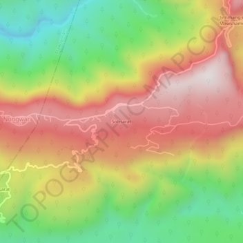
Name: Sohsarat topographic map, elevation, terrain.
Location: Sohsarat, Shella Bholaganj, East Khasi Hills, Meghalaya, India (25.19747 91.64414 25.23747 91.68414)
Average elevation: 562 m
Minimum elevation: 98 m
Maximum elevation: 1,011 m
Other topographic maps
Click on a map to view its topography, its elevation and its terrain.
Jymmang ne Mawshamok
India > Meghalaya > Shella Bholaganj
Jymmang ne Mawshamok, Shella Bholaganj, East Khasi Hills, Meghalaya, 793108, India
Average elevation: 654 m
Cherrapunji (Sohra)
India > Meghalaya > Shella Bholaganj > Cherrapunji (Sohra)
Cherrapunji (Sohra), Shella Bholaganj, East Khasi Hills, Meghalaya, 793108, India
Average elevation: 1,248 m
Nongriat
India > Meghalaya > Shella Bholaganj
Nongriat, Shella Bholaganj, East Khasi Hills, Meghalaya, 793108, India
Average elevation: 706 m