Geolocate

Altona topographic map

Click on the map to display elevation.

About this map

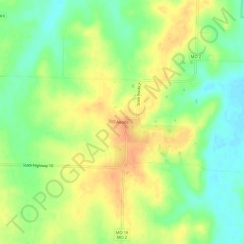
Name: Altona topographic map, elevation, terrain.

Location: Altona, Bates County, Missouri, United States (38.37974 -94.25495 38.41974 -94.21495)

Average elevation: 260 m

Minimum elevation: 240 m

Maximum elevation: 279 m

Other topographic maps

Click on a map to view its topography, its elevation and its terrain.

Amsterdam

United States > Missouri > Bates County

Average elevation: 273 m

Amsterdam

United States > Missouri > Bates County

Average elevation: 273 m

Rich Hill

United States > Missouri > Bates County

Average elevation: 244 m

Adrian

United States > Missouri > Bates County

Average elevation: 262 m

Adrian

United States > Missouri > Bates County

Average elevation: 262 m

Amoret

United States > Missouri > Bates County

Average elevation: 256 m

Gear up for your next adventure:

🧤Waterproof Overmitts - Extreme weather protection for hikers and mountaineers
🔦Waterproof LED Headlamps - Hands-free lighting for evening treks and emergency navigation
🧭Emergency Beacons - Safety beacons for remote outdoor locations
📸Action Camera Chest Mounts - Record your ascent following topographic paths hands-free
🐕Hiking Dog Harnesses - Rugged harnesses for taking your companion on mountain trails

As an Amazon Associate, this site earns from qualifying purchases at no extra cost to you.