
Riobamba topographic map
Click on the map to display elevation.
Riobamba
Riobamba (Spanish pronunciation: [rjoˈβamba], full name San Pedro de Riobamba; Quechua: Rispampa) is the capital of Chimborazo Province in central Ecuador, and is located in the Chambo River Valley of the Andes. It is 200 km (120 mi) south of Ecuador's capital Quito and located at an elevation of 2,754 m.
About this map
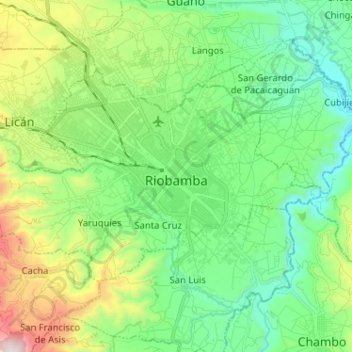
Name: Riobamba topographic map, elevation, terrain.
Location: Riobamba, Chimborazo, Ecuador (-1.71056 -78.72359 -1.63288 -78.59549)
Average elevation: 2,815 m
Minimum elevation: 2,465 m
Maximum elevation: 3,682 m