
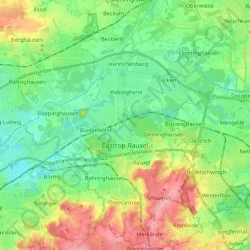
Castrop-Rauxel topographic map
Interactive map
Click on the map to display elevation.
About this map
Name: Castrop-Rauxel topographic map, elevation, terrain.
Average elevation: 75 m
Minimum elevation: 42 m
Maximum elevation: 137 m
Das Stadtgebiet von Castrop-Rauxel hat eine Fläche von insgesamt 51,66 km². Die Ausdehnung in Nord-Süd-Richtung beträgt 11,8 km und die West-Ost-Ausdehnung 9,3 km. Den höchsten Punkt der Stadt markiert die Halde Schwerin mit 147 m über NN, den niedrigsten die Pöppinghauser Straße neben Haus Nr. 264 mit 50,2 m über NN. Die mittlere Höhenlage beträgt 98,6 m über NN.
Other topographic maps
Click on a map to view its topography, its elevation and its terrain.
Im Berg
Deutschland > Nordrhein-Westfalen > Kreis Recklinghausen > Waltrop
Im Berg, Waltrop, Kreis Recklinghausen, Nordrhein-Westfalen, Deutschland
Average elevation: 64 m