Geolocate

Iritty topographic map

Click on the map to display elevation.

About this map

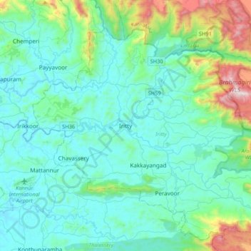
Name: Iritty topographic map, elevation, terrain.

Location: Iritty, Kannur, Kerala, 670703, India (11.94780 75.63687 12.02780 75.71687)

Average elevation: 65 m

Minimum elevation: 21 m

Maximum elevation: 221 m

Other topographic maps

Click on a map to view its topography, its elevation and its terrain.

Ulikkal

India > Kerala > Iritty > Nuchiyad

Average elevation: 161 m

Iritty

India > Kerala > Iritty

Average elevation: 65 m

Kottiyoor

India > Kerala > Iritty > Ambayathode

Average elevation: 394 m

Aralam WLS

India > Kerala > Iritty > Adakkathodu

Average elevation: 462 m

Aralam

India > Kerala > Iritty > Iritty

Average elevation: 86 m

Kelakam

India > Kerala > Iritty > Adakkathodu

Average elevation: 324 m

Gear up for your next adventure:

🧘Folding Sit Mats - Dry and warm seat for map-reading breaks on damp ground
🧢Waterproof Hiking Hats - Keep the rain off your face while studying topographic maps
🌦️Portable Weather Meters - Handheld tools for monitoring weather conditions
🍱Food Containers - Reusable containers for outdoor meals
🥾Walking Shoes - Lightweight walking shoes for countryside and coastal paths

As an Amazon Associate, this site earns from qualifying purchases at no extra cost to you.