
Pine Island topographic map
Interactive map
Click on the map to display elevation.
About this map
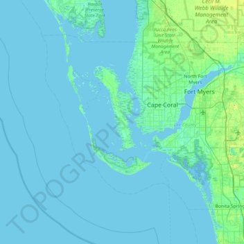
Name: Pine Island topographic map, elevation, terrain.
Location: Pine Island, Lee County, Florida, 33956, United States (26.23924 -82.41981 26.87924 -81.77981)
Average elevation: 2 m
Minimum elevation: -1 m
Maximum elevation: 24 m
Other topographic maps
Click on a map to view its topography, its elevation and its terrain.
Fort Myers
United States > Florida > Lee County
Fort Myers, Lee County, Florida, United States
Average elevation: 5 m
Estero
United States > Florida > Lee County
Estero, Lee County, Florida, 33928, United States
Average elevation: 7 m
Cape Coral
United States > Florida > Lee County
Cape Coral, Lee County, Florida, United States
Average elevation: 4 m
Fort Myers Beach
United States > Florida > Lee County
Fort Myers Beach, Lee County, Florida, 33931, United States
Average elevation: 1 m
Sanibel Island
United States > Florida > Lee County > Sanibel
Sanibel Island, Sanibel, Lee County, Florida, 33957, United States
Average elevation: 1 m
Bonita Beach Club
United States > Florida > Lee County > Bonita Springs
Bonita Beach Club, Bonita Springs, Lee County, Florida, 34134, United States
Average elevation: 0 m
North Fort Myers
United States > Florida > Lee County
North Fort Myers, Lee County, Florida, 33903, United States
Average elevation: 4 m
Shangri-La Mobile Home Park
United States > Florida > Lee County > Saint James City
Shangri-La Mobile Home Park, Saint James City, Lee County, Florida, 33956, United States
Average elevation: 1 m
Estero Bay
United States > Florida > Lee County
Estero Bay, Lee County, Florida, United States
Average elevation: 0 m
Cape Coral
United States > Florida > Lee County > Cape Coral
Cape Coral, Lee County, Florida, 33914-4648, United States
Average elevation: 3 m
Southern Pines
United States > Florida > Lee County > Bonita Springs
Southern Pines, Bonita Springs, Lee County, Florida, 34135, United States
Average elevation: 5 m
Saint James City
United States > Florida > Lee County
Saint James City, Lee County, Florida, 33956, United States
Average elevation: 1 m
Bokeelia
United States > Florida > Lee County
Bokeelia, Lee County, Florida, United States
Average elevation: 1 m
Orange River
United States > Florida > Lee County
Orange River, Lee County, Florida, United States
Average elevation: 7 m
Pelican Landing
United States > Florida > Lee County > Bonita Springs
Pelican Landing, Bonita Springs, Lee County, Florida, 34136, United States
Average elevation: 5 m
Bonita Springs
United States > Florida > Lee County
Bonita Springs, Lee County, Florida, United States
Average elevation: 5 m
Cape Coral
United States > Florida > Lee County
Cape Coral, Lee County, Florida, United States, Round Table Lake
Average elevation: 3 m
Telegraph Estates
United States > Florida > Lee County > Alva
Telegraph Estates, Alva, Lee County, Florida, United States
Average elevation: 6 m
Iona Gardens
United States > Florida > Lee County > Iona
Iona Gardens, Iona, Lee County, Florida, 33908, United States
Average elevation: 3 m
Moody River Estates
United States > Florida > Lee County > North Fort Myers
Moody River Estates, North Fort Myers, Lee County, Florida, 33903, United States
Average elevation: 3 m
Harlem Heights
United States > Florida > Lee County
Harlem Heights, Lee County, Florida, United States
Average elevation: 3 m
Sanibel
United States > Florida > Lee County
Sanibel, Lee County, Florida, United States
Average elevation: 1 m
Meres MHP
United States > Florida > Lee County > North Fort Myers
Meres MHP, North Fort Myers, Lee County, Florida, 33903, United States
Average elevation: 2 m
Pine Island Sound
United States > Florida > Lee County
Pine Island Sound, Lee County, Florida, 33945, United States
Average elevation: 0 m
San Carlos Bay
United States > Florida > Lee County
San Carlos Bay, Lee County, Florida, 03957, United States
Average elevation: 0 m
North Fort Myers
United States > Florida > Lee County > Fort Myers
North Fort Myers, Fort Myers, Lee County, Florida, 33903, United States
Average elevation: 7 m
New Pass
United States > Florida > Lee County > Bonita Springs
New Pass, Bonita Springs, Lee County, Florida, 34134, United States
Average elevation: 1 m
Little Carlos Pass
United States > Florida > Lee County > Bonita Springs
Little Carlos Pass, Bonita Springs, Lee County, Florida, United States
Average elevation: 1 m
Riverwoods Plantation
United States > Florida > Lee County
Riverwoods Plantation, Lee County, Florida, 33967, United States
Average elevation: 5 m
Spanish Wells
United States > Florida > Lee County > Bonita Springs
Spanish Wells, Bonita Springs, Lee County, Florida, 13434, United States
Average elevation: 6 m
Iona
United States > Florida > Lee County > Iona
Iona, Lee County, Florida, United States
Average elevation: 2 m
Caloosahatchee River
United States > Florida > Lee County
Caloosahatchee River, Lee County, Florida, United States
Average elevation: 8 m
Bokeelia
United States > Florida > Lee County
Bokeelia, Lee County, Florida, 33922, United States
Average elevation: 2 m
North Captiva Island
United States > Florida > Lee County
North Captiva Island, Lee County, Florida, 33945, United States
Average elevation: 1 m
Miromar Lakes
United States > Florida > Lee County
Miromar Lakes, Lee County, Florida, 33965, United States
Average elevation: 8 m
Blue Crab Key Condos
United States > Florida > Lee County
Blue Crab Key Condos, Lee County, Florida, 33922, United States
Average elevation: 3 m
San Carlos Park
United States > Florida > Lee County > San Carlos Park
San Carlos Park, Lee County, Florida, United States
Average elevation: 7 m
Limetree Park
United States > Florida > Lee County > Bonita Springs
Limetree Park, Bonita Springs, Lee County, Florida, 34134, United States
Average elevation: 5 m
Palm Lake RV Park
United States > Florida > Lee County > Bonita Springs
Palm Lake RV Park, 11401, Bonita Springs, Lee County, Florida, 34135, United States
Average elevation: 6 m
Royal Point at Majestic Palms
United States > Florida > Lee County > Iona
Royal Point at Majestic Palms, Iona, Lee County, Florida, 33908, United States
Average elevation: 4 m
Corkscrew Lakes
United States > Florida > Lee County
Corkscrew Lakes, Lee County, Florida, United States
Average elevation: 8 m
Wulfert
United States > Florida > Lee County > Sanibel
Wulfert, Sanibel, Lee County, Florida, 33926, United States
Average elevation: 1 m
Calusa Land Trust and Nature Preserve of Pine Island
United States > Florida > Lee County > Cape Coral
Calusa Land Trust and Nature Preserve of Pine Island, Cape Coral, Lee County, Florida, United States
Average elevation: 1 m
Caloosa Mobile Home Village
United States > Florida > Lee County > North Fort Myers
Caloosa Mobile Home Village, North Fort Myers, Lee County, Florida, 33903, United States
Average elevation: 2 m
Coral Lakes
United States > Florida > Lee County > Cape Coral
Coral Lakes, Cape Coral, Lee County, Florida, 33909, United States
Average elevation: 6 m
Saint James Mobile Home Park
United States > Florida > Lee County
Saint James Mobile Home Park, Lee County, Florida, 33956, United States
Average elevation: 1 m
Ybel
United States > Florida > Lee County > Sanibel
Ybel, Sanibel, Lee County, Florida, 33957, United States
Average elevation: 2 m
McDonough Canal
United States > Florida > Lee County > Cape Coral
McDonough Canal, Cape Coral, Lee County, Florida, 33991, United States
Average elevation: 3 m
Captiva Island
United States > Florida > Lee County
Captiva Island, Lee County, Florida, 33924, United States
Average elevation: 1 m
West Bay Club
United States > Florida > Lee County
West Bay Club, Lee County, Florida, 33928, United States
Average elevation: 4 m