
Cedar Crest topographic map
Interactive map
Click on the map to display elevation.
About this map
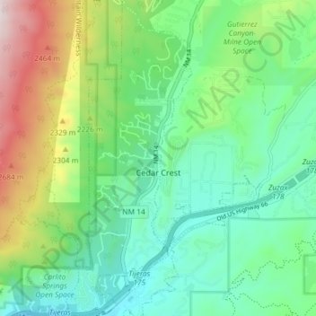
Name: Cedar Crest topographic map, elevation, terrain.
Average elevation: 2,169 m
Minimum elevation: 1,905 m
Maximum elevation: 2,812 m
Other topographic maps
Click on a map to view its topography, its elevation and its terrain.
Española
États-Unis > Nouveau-Mexique > Española > Espanola
Española, Espanola, Santa Fe County, Nouveau-Mexique, 87567, États-Unis
Average elevation: 1,750 m
McKinley County
McKinley County, Nouveau-Mexique, États-Unis
Average elevation: 2,124 m