

Make a donation
Gear up for your next adventure:
As an Amazon Associate, this site earns from qualifying purchases at no extra cost to you.
Naoussa topographic map
Click on the map to display elevation.
Make a donation
Gear up for your next adventure:
As an Amazon Associate, this site earns from qualifying purchases at no extra cost to you.
Naoussa
Naousa is located in Northwestern Imathia, 22 kilometers north of Veria and 90 kilometers west of Thessaloniki. The city lies on the eastern foothills of Vermio Mountains, one of the biggest mountain ranges in Greece, and west to the plain of Giannitsa. Naousa is today the largest forest-owning municipality in the country being also surrounded by orchards, producing peaches, apples, cherries and other fruits. Due to its location, the altitude varies by as much as 150m between the lowest and highest parts of the city, and it reaches nearly 550m in the Saint Nicholas Park. Naousa is crossed by the river Arapitsa forming a waterfall within the city.
Make a donation
Gear up for your next adventure:
As an Amazon Associate, this site earns from qualifying purchases at no extra cost to you.
About this map
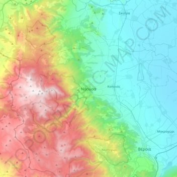
Name: Naoussa topographic map, elevation, terrain.
Average elevation: 652 m
Minimum elevation: 1 m
Maximum elevation: 2,053 m
Make a donation
Gear up for your next adventure:
As an Amazon Associate, this site earns from qualifying purchases at no extra cost to you.