
Halabja topographic map
Click on the map to display elevation.
Halabja
Halabja is located in the Shahrizor plain, a fertile valley nestled in the foothills of the Zagros Mountains in the Kurdistan Region of Iraq. The city's elevation is around 700 meters above sea level. The surrounding area is characterized by mountainous terrain, with the Hawraman Mountain range to the east, which plays a significant role in the city’s climate and geography. The region’s topography includes rolling hills and valleys, making it ideal for agriculture, particularly in the fertile plains.
About this map
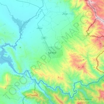
Name: Halabja topographic map, elevation, terrain.
Average elevation: 901 m
Minimum elevation: 447 m
Maximum elevation: 2,633 m