
Zahana topographic map
Interactive map
Click on the map to display elevation.
About this map
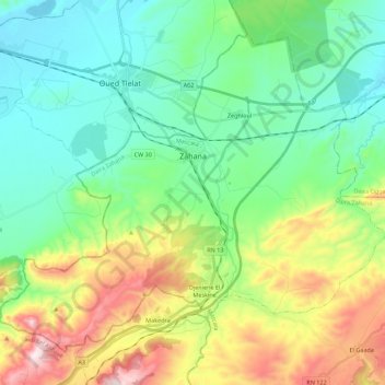
Name: Zahana topographic map, elevation, terrain.
Location: Zahana, Zahana District, Mascara, Algeria (35.42556 -0.52186 35.57533 -0.29984)
Average elevation: 284 m
Minimum elevation: 94 m
Maximum elevation: 731 m
Other topographic maps
Click on a map to view its topography, its elevation and its terrain.
Djeniene El Meskine
Algeria > Mascara > Zahana District > Zahana > Djeniene El Meskine
Djeniene El Meskine, Zahana, Zahana District, Mascara, Algeria
Average elevation: 363 m