
Oberstetten topographic map
Interactive map
Click on the map to display elevation.
About this map
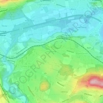
Name: Oberstetten topographic map, elevation, terrain.
Location: Oberstetten, Uzwil, Wahlkreis Wil, Sankt Gallen, 9249, Schweiz (47.42794 9.07003 47.46794 9.11003)
Average elevation: 554 m
Minimum elevation: 500 m
Maximum elevation: 702 m
Other topographic maps
Click on a map to view its topography, its elevation and its terrain.
Rütiwes
Schweiz > Sankt Gallen > Wahlkreis Wil > Uzwil > Henau
Rütiwes, Henau, Uzwil, Wahlkreis Wil, Sankt Gallen, 9247, Schweiz
Average elevation: 554 m