
Ain Larbi topographic map
Interactive map
Click on the map to display elevation.
About this map
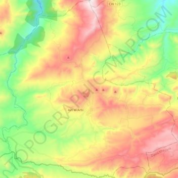
Name: Ain Larbi topographic map, elevation, terrain.
Location: Ain Larbi, Ain Makhlouf District, Guelma, Algeria (36.20951 7.30533 36.36014 7.48984)
Average elevation: 830 m
Minimum elevation: 365 m
Maximum elevation: 1,397 m
Other topographic maps
Click on a map to view its topography, its elevation and its terrain.
Ain Makhlouf
Algeria > Guelma > Ain Makhlouf District > Ain Makhlouf
Ain Makhlouf, Ain Makhlouf District, Guelma, 24013, Algeria
Average elevation: 786 m
Tamlouka
Algeria > Guelma > Ain Makhlouf District > Tamlouka
Tamlouka, Ain Makhlouf District, Guelma, Algeria
Average elevation: 840 m