
Make a donation
Gear up for your next adventure:
As an Amazon Associate, this site earns from qualifying purchases at no extra cost to you.
Vorst topographic map
Click on the map to display elevation.
Make a donation
Gear up for your next adventure:
As an Amazon Associate, this site earns from qualifying purchases at no extra cost to you.
About this map
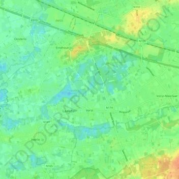
Name: Vorst topographic map, elevation, terrain.
Location: Vorst, Laakdal, Turnhout, Antwerpen, Vlaanderen, 2430, België (51.07289 4.98907 51.10432 5.10038)
Average elevation: 19 m
Minimum elevation: 7 m
Maximum elevation: 41 m
Make a donation
Gear up for your next adventure:
As an Amazon Associate, this site earns from qualifying purchases at no extra cost to you.
Other topographic maps
Click on a map to view its topography, its elevation and its terrain.
Sint-Jozef-Olen
België > Antwerpen > Turnhout > Olen
Sint-Jozef-Olen ligt ten zuiden van het Kanaal Bocholt-Herentals op een hoogte van ongeveer 18 meter. Ten noorden van het kanaal, en min of meer parallel daarmee, loopt de Kleine Nete. Een natuurgebied in de vallei van de Kleine Nete is het Olens Broek en Langendonk.
Average elevation: 16 m
Make a donation
Gear up for your next adventure:
As an Amazon Associate, this site earns from qualifying purchases at no extra cost to you.
Ezaart
België > Antwerpen > Turnhout > Mol
Een ander verhaal over de herkomst van Ezaart gaat over een boer en zijn koppige ezel. Om het dier toch te kunnen voortbewegen, trok men zo hard aan zijn staart, dat deze werd afgerukt. De letters "ez" staan voor ezel, en "aart" voor staart. Ter hoogte van het kapelletje "Onze Lieve Vrouw in Nood" staat…
Average elevation: 25 m
Make a donation
Gear up for your next adventure:
As an Amazon Associate, this site earns from qualifying purchases at no extra cost to you.
Make a donation
Gear up for your next adventure:
As an Amazon Associate, this site earns from qualifying purchases at no extra cost to you.
Make a donation
Gear up for your next adventure:
As an Amazon Associate, this site earns from qualifying purchases at no extra cost to you.
Heuvelrug tussen Lichtaart en Kasterlee
België > Antwerpen > Turnhout > Kasterlee
Average elevation: 17 m
Make a donation
Gear up for your next adventure:
As an Amazon Associate, this site earns from qualifying purchases at no extra cost to you.
Make a donation
Gear up for your next adventure:
As an Amazon Associate, this site earns from qualifying purchases at no extra cost to you.
Postel
België > Antwerpen > Turnhout > Mol
Postel ligt ongeveer op de waterscheiding van het Maas- en Scheldebekken. Ten noorden van Postel wateren de beekjes af naar de Maas, terwijl de beekjes ten westen en zuiden naar de Nete lopen. De abdij van Postel ligt op een hoogte van ongeveer 38 meter. Het hoogste punt in de buurt is 43 meter.
Average elevation: 35 m
Make a donation
Gear up for your next adventure:
As an Amazon Associate, this site earns from qualifying purchases at no extra cost to you.
Make a donation
Gear up for your next adventure:
As an Amazon Associate, this site earns from qualifying purchases at no extra cost to you.
Rauw
België > Antwerpen > Turnhout > Mol
Rauw is een van de twaalf gehuchten van de Belgische gemeente Mol. De plaats ligt echter dichter bij de kernen van Lommel en Balen, dan bij het centrum van Mol zelf en wordt ook wel aangeduid als een kerkdorp. Op sommige topografische kaarten wordt Rauw als Rouw of Het Rouw aangeduid.
Average elevation: 35 m
Make a donation
Gear up for your next adventure:
As an Amazon Associate, this site earns from qualifying purchases at no extra cost to you.
Make a donation
Gear up for your next adventure:
As an Amazon Associate, this site earns from qualifying purchases at no extra cost to you.
Make a donation
Gear up for your next adventure:
As an Amazon Associate, this site earns from qualifying purchases at no extra cost to you.
Make a donation
Gear up for your next adventure:
As an Amazon Associate, this site earns from qualifying purchases at no extra cost to you.
Rijkevorsel
België > Antwerpen > Turnhout > Rijkevorsel
Rijkevorsel ligt in de Noorderkempen op een hoogte van 17-30 meter. Rijkevorsel ligt nabij de Kleine Mark die in noordelijke richting stroomt. Het Kanaal Dessel-Turnhout-Schoten verloopt ten zuiden van de kom in oost-westrichting. Kleilagen in de ondergrond zorgden voor baksteenindustrie waarbij kleiputten…
Average elevation: 24 m
Make a donation
Gear up for your next adventure:
As an Amazon Associate, this site earns from qualifying purchases at no extra cost to you.
Make a donation
Gear up for your next adventure:
As an Amazon Associate, this site earns from qualifying purchases at no extra cost to you.
Voortkapel
België > Antwerpen > Turnhout > Westerlo
Voortkapel ligt in de Kempen op een hoogte van ongeveer 13 meter.
Average elevation: 15 m
Make a donation
Gear up for your next adventure:
As an Amazon Associate, this site earns from qualifying purchases at no extra cost to you.