
Thank you for supporting this site ❤️
Make a donation
Make a donation
Gear up for your next adventure:
As an Amazon Associate, this site earns from qualifying purchases at no extra cost to you.
Ashton topographic map
Click on the map to display elevation.
Thank you for supporting this site ❤️
Make a donation
Make a donation
Gear up for your next adventure:
As an Amazon Associate, this site earns from qualifying purchases at no extra cost to you.
About this map
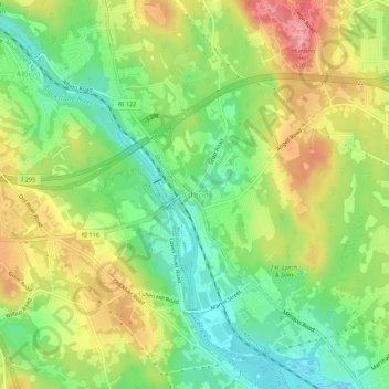
Name: Ashton topographic map, elevation, terrain.
Average elevation: 60 m
Minimum elevation: 10 m
Maximum elevation: 123 m
Thank you for supporting this site ❤️
Make a donation
Make a donation
Gear up for your next adventure:
As an Amazon Associate, this site earns from qualifying purchases at no extra cost to you.
Other topographic maps
Click on a map to view its topography, its elevation and its terrain.
Diamond Hill Park
United States > Rhode Island > Providence County > Cumberland > Diamond Hill
Average elevation: 83 m
Conservation Land (Trails)
United States > Rhode Island > Providence County > Cumberland
Average elevation: 73 m